This URL is for Sale: Phone or Text (240) 559-853
This URL is for Sale: Phone or Text (240) 559-853
This URL is for Sale: Phone or Text (240) 559-853

The original land tract in 1694 consisted of 3,697 acres (5.78 square miles), in what is now North Bethesda, was known as Dan, named after Daniel Elliott (probably of Scottish descent), who was court appointed as the constable of New Scotland, which at that time was the name the English colonists applied to a vast unsettled region.
Before the establishment of counties that we would recognize, the region extending from Oxon Creek (what is now the Prince George's County line) to the Little Falls on the Potomac River (what is now the D.C. line) was called New Scotland Hundred. This region extended northward jus beyond Lake Needwood. It was one of six unsettled designated areas in Mary Land known as hundreds. And Daniell Ellets was the Constable For New Scotland Hundred. His name also comes up in old public records from the period as an appraiser.
A mapp of Virginia discovered to ye hills, and in it's latt. from 35 deg. & 1/2 neer Florida to 41 deg. bounds of New England, London 1667, Library of Congress
- See Below -

“Here the Roman Catholick, and the Protestant Episcopal (whom the world would perswade have proclaimed open Wars irrevocably against eaeh other), contrarywise concur in an unanimous parallel of friendship, and inseparable love intayled into one
another: All Inquisitions, Martyrdom, and Banishments are not so much as named, but unexpressably abhorr'd by each other.”
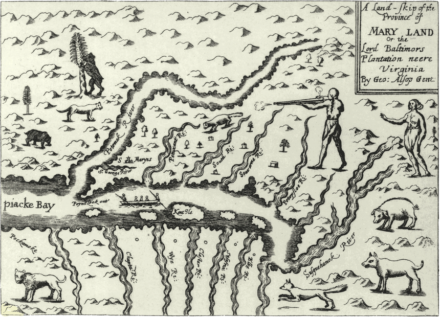
George Alsop, “A CHARACTER of the PROVINCE of MARY-LAND, Wherein is Described in four distinct parts,” Gowan's bibliotheca americana, 1845-1869
(History of the Colonial Period, between 1600-1775)
- See Above -
Cecil Calvert, 2nd Baron Baltimore (August 8, 1605 – November 30, 1675), was an English nobleman who was the first Proprietor of the Province of Maryland with the title of First Lord Proprietary, Earl Palatine of the Provinces of Maryland and Avalon in America. With vast maps and the allure of land tracts, publications - like the one above, which was not true - were used as inducements to allure settlers to sail, settle, work, produce, and, of course, pay taxes for his lordship's much needed revenues. In 1634, settlers came to Maryland on the ship named the Dove.
Charles County was established in 1658 and had no northern limit except "as far as the settlements extended."
The state's banner is made up of the Calvert family banner in the yellow and black chevron and that of the paternal grandmother of Cecil Calvert, the Crossland family, in the red and white cross.

In April 1696, the English Council of Maryland in the Province of Maryland created Prince George's County from out of Charles and Calvert counties. (The county was named after Prince George of Denmark (1653–1708), the consort of Anne, Queen of Great Britain). The colonial period in Maryland was from 1632 and 1776, and Montgomery County was established after the thirteen British colonies declared their independence from England. On September 6, 1776, Thomas Sprigg Wootton from Rockville introduced legislation while serving at the Maryland Constitutional Convention to create lower Frederick County as Montgomery County. The county is named after Major General Richard Montgomery, who fought in the Revolutionary War, and died in 1775 in the Battle of Quebec.

The 181 acre tobacco plantation at 201 Port Tobacco Road in Charles County, Maryland near Port Tobacco called La Grange was built by Dr. James Craik, a Scottish doctor, who had served as a surgeon in Colonel Fry's regiment of the Continental Army, and was a personal friend of George Washington having accompanied him into the Ohio Valley. La Grange was then managed by William Craik, the doctor’s son, for 10 years, and then sold to Frances Newman.

Plantation owner, "gentleman farmer," Frances Newman was born in 1759 at Hinckley in Leicestershire, England. He held at least 23 slaves at La Grange, and sold Josiah Henson while a child to Adam Robb of Rockville, and then to Isaac Riley. "Henson’s owner at the time, Francis Newman, the owner of La Grange, was a con artist and bigamist who left his wife in England to settle in Port Tobacco with the wife of another man," as reported by Jamie Anfenson-Comeau of the Maryland Independant and easily confirmed in the Newman Family Tree records posted online.

Josiah Henson was born into slavery on June 15, 1789 on the La Grange plantation. Isaac Riley of the 520 acre Willow Grove plantation in Montgomery County purchased Josiah Henson as a child thus separating the boy, aged between 6 and 8, from his mother.
"The Riley family," according to John Milner Associates, Inc., "owned several farms of hundreds of acres each. The farm that the Collyar family sold to George Riley in 1797 (in other words the acreage associated with the current house) was known by deed as “Collyar’s Resurvey” because it had been re- surveyed in 1787 and found to contain 282 1⁄2 acres."
"George Riley ... was assessed for 20 enslaved persons, six of whom were under the age of eight. ... The 1850 slave census listing for Isaac Riley shows five enslaved individuals, four of whom are children."
Josiah Henson's freedom can be accredited to Amos Riley of Daviess County, Kentucky, who undid the malintent of his brother Isaac to have him sold down river in New Orleans.
Mr. Henson grew to become a key figure in the abolitionist movement that stretched across Europe, the United Staes, and Canada. Both Henson's 1849 autobiography The Life of Josiah Henson, Formerly a Slave, Now an Inhabitant of Canada and Harriet Beecher Stowe’s 1852 novel Uncle Tom’s Cabin put the issue of slavery and its abolishment front and center on the national consciousness.


Harriet Beecher-Stowe was born June 14, 1811 in Litchfield, Connecticut and died July 1, 1896 at the age of 85 in Hartford, Connecticut. Her father was the president of the Lane Theological Seminary in Cincinnati, Ohio beginning in 1832, and the Presbyterian seminary became the venue for the 1834 Slavery Debates. See the 1836 Slave Market of America circular published by the Quaker organization the American Anti-Slavery Society (held by the Library of Congress). Harriet Beecher-Stowe grew to become a key figure in the American abolitionist movement and author of Uncle Tom's Cabin - authored at the age of 41. (Portrait of Stowe by Alanson Fisher 1853, National Portrait Gallery, Washington, D.C.). Uncle Tom's Cabin energized the North's sentiments to oppose slavery and enraged the plantation owners in the South. Harriett's brother Henry Ward Beecher raised funds to purchase the freedom of slaves and to also send "Beecher Bibles" - rifles - to abolitionists in Kansas and Nebraska.
Henry Ward Beecher and John Brown found common cause in Kansas over the abolitionist's movement work to block slavery in Kansas. The history of what played out in Kansas laid the groundwork for the Civil War.
"Abolitionist John Brown was a conductor on the Underground Railroad," per the History Channel, "during which time he established the League of Gileadites devoted to helping fugitive slaves get to Canada." In John Brown, a Bible believer, one man’s freedom fighter became another man’s terrorist. Brown was indeed in the moral right to demand the liberation of the enslaved peoples from Africa - those, who had been reduced to the legal status of property by a deranged Republic dominated by Freemasons and even regarded by many as a curiosity of God’s creation belonging to a pre Adamic race and beyond the pale of redemption. Brown engaged in a raid on Harper's Ferry, and was hanged by the neck until dead in Charlestown, West Virginia in 1859 for his valiant, but failed efforts.
When Harriet Beecher-Stowe was introduced to President Abraham Lincoln on Thanksgiving Day in 1862 he is alleged to have said, "So you're the little woman who wrote the book that made this great war!" To this day, Harriet Beecher-Stowe's Uncle Tom's Cabins "is remembered as instrumental in sparking a necessary conflict over slavery."
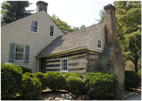
George Riley purchased 520 acres at this location in 1797 from James Collyer, and that was the size of the Riley Plantation known as Willow Grove that Josiah Henson and other slaves worked.
By 1863, the plantation had diminished to 260 acres, and that stretched out to what is now Executive Boulevard to the north and toward Luxmanor Elementary School to the south making up what is today Luxmanor, Neilwood, Hollyoak, Old Georgetown Estates, and part of Tilden Woods.
Isaac Riley (1774 - 1850) and Matilda Middleton Riley (1800 - 1890) were married in 1818, and are buried just down the road at the Mount Zion Cemetery at the Wildwood Baptist Church located at 10200 Old Georgetown Road in Bethesda across the street from the Wildwood Shopping Center.
Josiah Henson (1789 - 1883) is buried in Dresden, Ontario, Canada.
Uncle Tom's Cabin Historic Site
29251 Uncle Tom's Road R.R. #5
Dresden, Ontario, Canada
According to the first census of 1790 in Montgomery County, 18,000 people lived in the county, and about 35 percent were Africans, or 6,300 people. Before the Emancipation Proclamation of January 1, 1863 - the third year of the Civl War - slaves either kept their head low, purchased their freedom if they could, or became fugitives and fled along the Underground Railroad by way of the Quakers in Sandy Spring, Maryland so that they could find safe harbor in Canada. Also, prior to that date if they fled into Washington, D.C., which many did, they found themselves as contrabands of war as they still lacked the legal status of personhood.
Confederate General Jubal Early camped on the grounds of the Riley Plantation, conducted a raid on Washington, D.C. on July 11, 1864, and ended up in a skirmish at Rabbitt's Creek (on Samuel Rabbit's property in Bethesda) as he headed towards Fort Stevens. Mt. Zion Baptist Church on Old Georgetown Road served as a field hospital.
According to the 1867 Slave Statistics, over 3,449 slaves, including those who labored on the Isaac Riley Farm, gained their freedom in Montgomery County. Their descendants, more than likely, live in nearby communities like Scotland in Potomac, Maryland only to find themselves displaced as real estate speculators came in 100 years later to develop what became Cabin Mall.

(Photo courtesy of Judith Wellman)
Josiah Henson Special Park Master Plan
approved and adopted
December 2, 2010.
11420 Old Georgetown Road
North Bethesda, MD 20852
Sits on 3.34 acres comprised of the original historic structures plus four adjacent properties.
Josiah Henson Park opens to the public Summer 2020.
National Register of Historic Places.
Provide interpretive programming of the Riley house, 1850s log kitchen grounds and archaeological sites.
The site will have a Visitor Center built on the adjacent property.
See the PBS Special on the Josiah Henson house and property.
1/6


OF 02 O'Neale Prichard Farm, Riley Plantation, Josiah Henson, Smokehouse
HEBERT PUBLISHERS, A Limited Liability Company
Copyright © 2019, 2020, 2021 North Bethesda Magazine - All Rights Reserved.
For image, map, or content reuse, please feel free to contact us.
Powered by GoDaddy